Upload a photo to start editing
Free GPS Map Camera Editor – Add Location, Date & Time to Photos
Upload a photo and edit GPS location stamps online. Add map location, latitude, longitude, date and time to your photos instantly using our free GPS Map Camera Editor. No download required — all photos are processed securely in your browser.
Professional GPS Photo Editor Online
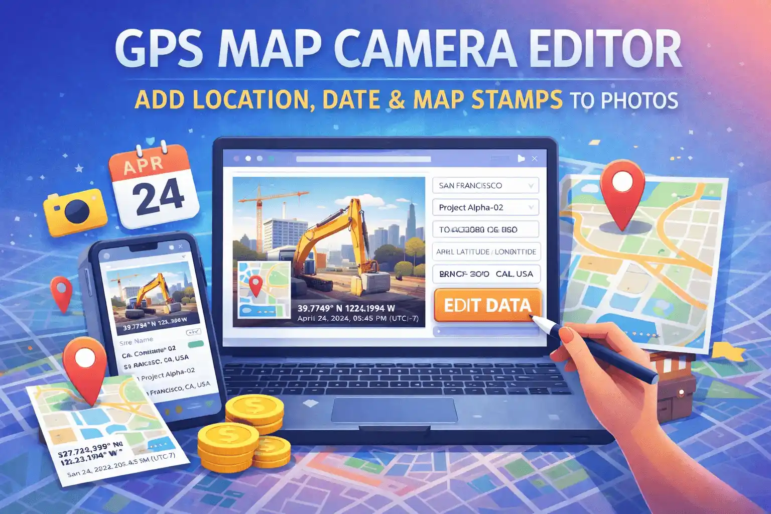
Our GPS Map Camera Editor is the industry-leading browser utility for adding precise geolocation data to existing photographs. In professional sectors like construction, civil engineering, and law enforcement, a photo without context is often inadmissible. Whether you are fixing a missing geotag due to poor satellite reception or adding a professional stamp for a corporate report, this tool provides a fast, secure, and zero-install solution. It functions exactly like a professional GPS camera online, allowing you to "burn" permanent location data into any image captured on your device.
Key Features of the Editor
- Add GPS location stamps to any gallery photo
- Use the photo date editor online to sync timestamps
- Customizable map overlays (Satellite coming soon)
- Project and site name fields for professional reporting
- High-compression JPG and PDF output formats
Why Professionals Choose Browser-Based Geotagging
In 2026, data privacy and workflow speed are the primary concerns for field documentation. Traditional mobile apps are often "heavy," consuming device storage and potentially tracking user location in the background. Our GPS Map Camera Editor operates entirely on the client side. This means your sensitive site photos are processed in your browser's memory and never uploaded to a cloud server, ensuring 100% compliance with corporate privacy policies and GDPR/CCPA standards.
If you are looking to capture *new* photos with automated live stamping, we recommend using our primary GPS Map Camera Online tool for real-time verification.
How to Use GPS Map Camera Editor Online
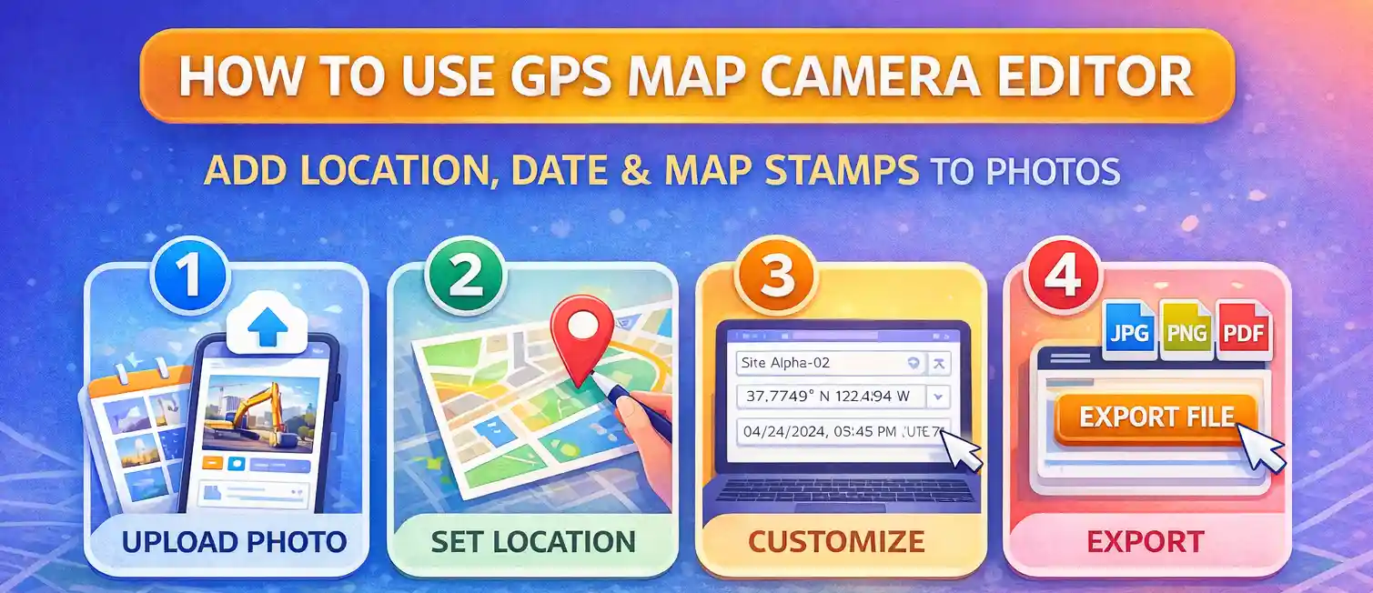
Geotagging a photo with our editor is designed to be frictionless for field workers. Follow these steps for the best results:
- Upload Photo: Select the image from your mobile gallery or desktop folder. The tool supports JPG, PNG, and WebP formats.
- Calibrate Location: Use the live search bar to find an address or manually drag the red map marker. Our Leaflet-powered map ensures you can pinpoint the exact spot, even in rural or unmapped construction sites.
- Metadata Customization: Verify the coordinate strings and the timestamp. If your device's clock was off, this is where you use the photo date editor feature to correct the time.
- Professional Export: Select "PDF" for official government submissions or "JPG" for quick email updates, then click EXPORT EDITED FILE.
Use Cases for GPS Map Camera Editor
This tool is widely utilized across various global industries to maintain a "Document of Truth":
- Construction & Engineering: Proving work completion at specific coordinates to unlock milestone payments.
- Insurance Adjusters: Verifying the exact location and time of property damage or vehicle accidents.
- Real Estate Compliance: Providing verifiable address stamps for property appraisals and listings to prevent fraud.
- Logistics & Supply Chain: Using stamped photos as "Proof of Delivery" (POD) in areas where digital signatures aren't feasible.
- Environmental Surveys: Tracking wildlife sightings or soil samples with immutable GPS coordinate stamps.
Safety and Data Integrity
Unlike many "free" online tools, we prioritize your security. Built by developer Priyanshu Borah, this platform uses the W3C Geolocation API and HTML5 Canvas rendering. This ensures that the "Chain of Custody" for your digital evidence remains entirely on your device. For a deep dive into the technical standards we follow, please read our guide on using GPS photos for legal proof.
Frequently Asked Questions
Can I edit the GPS location of an existing photo?
Yes, our GPS Map Camera Editor allows you to upload any photo and manually search or select a new location to apply a stamp.
Is the GPS photo editor free to use?
Yes, the editor tool is 100% free and processes all images directly in your browser for maximum privacy.
What file formats does the editor support?
You can export your edited photos as JPG, PNG, or professional PDF documents.
Can I add a location to a photo taken in a remote area?
Yes. Even if the photo was taken in a "dead zone" without an address, you can use our manual coordinate input to enter the exact latitude and longitude, which the tool will then convert into a visual map stamp.