How to Add GPS Location to Photos Online (Free & No App)
In today's fast-paced professional world, a simple image isn't always enough to close a report or verify a claim. Whether you are a field engineer documenting a bridge inspection, a real estate agent validating a property listing, or a nature traveler wanting to log a rare sighting, having a visual record of exactly where and when a photo was taken is invaluable. While smartphones have built-in GPS capabilities, the data is often hidden—making it difficult to share as "proof."
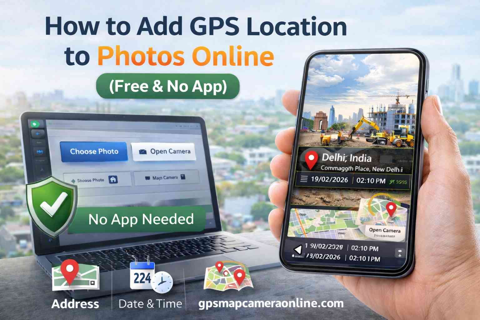
This guide will walk you through the most efficient, privacy-friendly way to add GPS location to photos online using a browser tool, eliminating the need for bulky app store downloads.
Table of Contents
Why Visual Stamps are Better Than Hidden Metadata
Many users mistakenly assume that since their phone has GPS enabled, their photos are "already tagged." While technically true (via EXIF metadata), this data is "invisible" to the average viewer and is frequently stripped away by social media platforms and messaging apps like WhatsApp or Facebook. A visual stamp is embedded directly into the photo's pixels, making the location and time data permanent and unchangeable.
As explored in our guide on location without EXIF, visual stamping is the industry standard for 2026. It ensures that the coordinates remain visible even if the file format is converted or shared through privacy-stripping channels.
How Browser Geolocation Works
Modern browsers like Chrome and Safari use the W3C Geolocation API. When you use an online GPS Map Camera, the browser requests access to your hardware's GPS sensor. Unlike apps that might track you in the background, a web tool only sees your location when the tab is active and you give explicit consent. This makes it a significantly safer and more "on-demand" way to geotag your media.
How to Add GPS Location to Photos Online (Step-by-Step)
Our tool simplifies complex GIS (Geographic Information System) mapping into a user-friendly three-click process:
Step 1: Initiation
Go to the GPS Map Camera Online homepage. You have two options: Click "Choose Photo" to upload an existing image from your local storage, or click "Open Camera" to capture a live, timestamped photo directly through your browser.
Step 2: Authorization
A popup will appear asking for location access. Click "Allow." The tool will then communicate with satellites and local Wi-Fi nodes to pinpoint your latitude, longitude, and current street address. You will see a live map update in the sidebar to confirm accuracy.
Step 3: Customization & Stamping
Scroll through the Template Gallery. You can choose a minimal design or a comprehensive "Separated Boxes" layout that includes a map thumbnail. Once you hit "Save Stamped Photo," the final image is generated locally in your browser and saved to your downloads folder.
Professional & Government Use Cases
Visual photo stamping has moved from a "cool feature" to a professional requirement in many sectors:
- Government Officials: Used for verifying land records and state-funded project completions. A photo with a hard-coded stamp is much harder to dispute in a court of law.
- Civil Engineering: Documenting the exact pillar or segment being inspected on a 50km highway project where addresses aren't available—only coordinates matter.
- Insurance Adjusters: Verifying that a damage claim was indeed photographed at the claimant's insured address.
- Remote Attendance: Many organizations now accept GPS-stamped "site selfies" as proof of attendance for remote workers in rural or unconnected areas.
Privacy You Can Trust
The biggest risk with many "Free GPS Apps" in the app stores is data harvesting. Many of these apps sell your location history to advertisers. Our tool uses client-side processing. This means the "stamping" happens on *your* processor, inside *your* browser. Your private photos never touch our servers, ensuring 100% confidentiality for sensitive site data.
Technical Tips for Better GPS Accuracy
To ensure your stamps are as accurate as possible, keep these tips in mind:
- Step Outside: If you are indoors, GPS signals can bounce off walls, causing "GPS drift." For high-accuracy site reports, always step outside for a clear sky view.
- Wait for the Lock: Give the tool 5-10 seconds to "lock" onto a signal. Modern GPS is fast, but multiple satellite connections provide much higher precision.
- Enable High Accuracy: In your device's system settings, ensure that "High Accuracy" location (using GPS, Wi-Fi, and mobile networks) is enabled.
🏆 Quick Verdict
When comparing GPS Map Camera Online vs Mobile Apps, the web-based utility is the clear winner for 2026 due to its privacy, zero storage impact, and universal compatibility across all operating systems.
Frequently Asked Questions
Ready to make your location data permanent?
Join thousands of professionals using our tool to geotag their reports daily. Fast, free, and no app required.
Start Stamping Photos Now